30 April 2017

The Telephone Exchange, Georgetown

The Post and Telecommunications Department of British Guiana maintained and operated the inland public telephone. telegraphy and radio systems. The main telephone exchanges were in Georgetown, New Amsterdam and Mackenzie. There were also sub-exchanges, call offices and private exchanges that ensured a widespread accessibility of these services. Cable and Wireless Ltd. operated and maintained overseas radio-telephone services and radio communications with sea ships. The image shows the Georgetown telephone exchange in 1918 British Guiana.


Sources

[image] - Unknown


29 April 2017

The Mazaruni Penal Settlement, Essequibo

The Mazaruni Penal Settlement is located at the intersection of the Mazaruni and Essequibo Rivers. The official impetus to create the facility began around 1841 and completed in stages. The facility contained cells (10 feet x 15 feet) for the male and female prisoners, guards housed at each end of the cells, superintendent quarters, kitchen spaces, hospital, chapel, observatory tower, and a work area to process quarry materials. At the time of completion the prison was able to accommodate seventy-one prisoners. The name "Settlement" suggested a goal to be a self-sufficient and socially-organized space. Life on the Settlement was regimented - prisoners wore partially processed cotton (Calico) clothing, were allowed two minutes to wash themselves in the river, and received half-a-pound of bread with a pint of molasses and water for supper. Prisoners processed rocks from the nearby quarry to be used for road-building. The Amerindian villages around the area would assist in the capture of escaped prisoners as there was substantial reward. The sketches and images show scenes from the Mazaruni Penal Settlement in British Guiana.

Image 01 - Prisoners breaking stones (1888).

Image 02 - Prisoners going to bathe (1888).

Image 03 - A prisoner (1888).

Image 04 - A prison warden (1888).

Image 05 - View of the penal settlement from the river (1888).

Image 06 - The Chapel (1895).

Image 07 - Discharged convicts waiting for the boat (1895).

Image 08 - View of the penal settlement (1898).

Image 09 - View of the penal settlement (1898).

Image 10 - Warden quarters (1905).


Image 11 - The Cottage, Superintendent's house (1905).

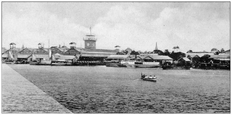
Image 12 - View of the penal settlement from the river (1910).

Image 13 - The landing stage (1912).

Image 14 - The landing stage (1915).

Image 15 - Perspective view of the penal settlement (1921).

Image 16 - Perspective view of the penal settlement (1921).

Sources

[Image 01] - Illustrated News of London, England, 1888-05-12.
[Image 02] - Illustrated News of London, England, 1888-05-12.
[Image 03] - Illustrated News of London, England, 1888-05-12.
[Image 04] - Illustrated News of London, England, 1888-05-12.
[Image 05] - Illustrated News of London, England, 1888-05-12.
[Image 06] - Unknown.
[Image 07] - Illustrated News of London, England, 1895.
[Image 08] - H.K.L von Ziegesar, Georgetown, British Guiana, 1898.
[Image 09] - Unknown.
[Image 10] - H.P. Kaps Jeweller, Georgetown, Demerara, 1905.
[Image 11] - H.K.L von Ziegesar, Georgetown, British Guiana, 1905.
[Image 12] - Unknown.
[Image 13] - Unknown.
[Image 14] - H.P. Kaps Jeweller, Georgetown, Demerara, 1915.
[Image 15] - UK National Archives, 1921.
[Image 16] - UK National Archives, 1921.


Bibliography


The British Guiana Mutual Building, Georgetown

The British Guiana Mutual building was the home of the British Guiana Mutual Fire Insurance Company established in 1880 to provided fire and general insurance services. In 1925, life insurance was added to the list of available insurance service. The image shows the British Guiana Mutual building in 1924 British Guiana.


Sources

[image] - Unknown


27 April 2017

Demerara Rowing Club, Georgetown

Rowing was an organized sport in British Guiana. There was a clubhouse located in La Penitence, with swimming and rowing competitions done in the Demerara River close to Stabroek Market. The image shows the rowing clubhouse in 1924 British Guiana.


Sources

[image] - Unknown


Croal Street, Georgetown

In 1835 the Scotsman John Croal served as the Commissioner of Compensation of the Slavery Bill. In 1834 he became the first Mayor of Georgetown and Croal Street is named in his honor. In 1838 he was the joint owner (with Peter Rose) of five plantations. John Croal died on 15th May 1853 and was buried at the Bourda Cemetery. The image shows a scene from Croal Street in 1910 British Guiana.


Sources

[image] - Unknown


Middle Street, Georgetown

In 1807 Thomas Cumming bought the La Bourgade parcel of land and renamed it Plantation La Bourgade Cummingsburg. Cummingsburg had fresh water reservoirs containing fishes and lilies. Middle Street was named because it was the middle dam of Plantation La Bourgade. These water reservoirs were later filled-in to provide walkways.

Image 01 - Middle Street, Georgetown (1910)

Image 02 - Middle Street, Georgetown (1915)

Sources

[image 01] - Unknown
[image 02] - Unknown


26 April 2017

Fort Kyk-Over-Al, Essequibo

Fort Kyk-Over-Al was constructed in 1616 and completed in around 1623 by the Dutch in the colony of Essequibo at the intersection of the Cuyuni and Mazaruni rivers. The name Kyk-Over-Al translates to mean "see over all" since the Fort had a bird-eye view of the river. The terrain elevation at the location is estimated to be about 6 feet above mean sea level. The Fort had two floors; a ground floor for storage of ammunition and food, and a top floor for dwelling quarters of the soldiers. Today only the entry arch remains. The image shows the arch in 1921 British Guiana.


Sources

[image] - Unknown


High Street, Georgetown


High Street was built in 1797 as the main road from the East Bank to the East Coast of Demerara. Sections of High Street were subsequently renamed such as Main Street.
 
Image 01 - High Street at Church Street (1890s)

 Image 01 - Towards the southern end of High Street (1912)

Image 02 - High Street (1915)

Sources:

[image 01] - Unknown
[image 02] - Unknow
[image 03] - Unknown 


25 April 2017

Loading the Sugarcane Punts

Sugarcane was one of the major agricultural crops in British Guiana. The process was largely manual work. The workers harvest the sugarcane and load them on to the punts for transport to the next stage. The punts were pulled by ox or tractor along an intricate network of canals leading to the sugarcane processing factory for unloading. Sugar and rum were the main end-products. The image shows the sugarcane loaded on to punts and the navigation of the punts along the canal in British Guiana.

Image 01 - Sugarcane punts and navigation canals (1908)

Image 02 - Heading out sugarcane to punts (1924)

Sources

[Image 01] - Unknown
[Image 02] - Unknown


The Globe Theatre, Georgetown

The Globe Theatre was both a playback cinema and live auditorium for public events. There were about 1,400 seats organized into balcony, box and pit. Musical legends such as Mahalia Jackson, Mohammed Rafi and Mukesh performed live at the Globe. The congresses of political parties were also held there. The image shows the Globe Theatre in 1949 British Guiana.


Sources
[image] Ferreira, J.P. The Daily Chronicle Limited, 1949


The Townhall of Georgetown, Demerara

The Townhall of Georgetown was opened on 1st July 1889 by Lord Gormanston who was Governor of the Colony at the time. Georgetown had about 50,000 citizens and the Mayor and Corporation requested in 1887 for a townhall to be built for the municipality. The ground floor consisted of a Fire Brigade depot. The first floor contained several municipal offices. The upper floor contained the Assembly Room (90 feet x 40 feet) for public meetings and concerts. The central tower rises about 100 feet from ground level and was the look-out for the fire-watch. The building was  adorned with the arms of the colony (a ship in full sail) and the motto "Damus petimusque vicissim" which is the Latin for "We give and take in return". The building was designed by Reverend Ignatius Scoles S.J. with the contractors being Sproston, Son and Co. of London and Demerara. The image shows the Georgetown Townhall in 1889 British Guiana.


Sources
[image] Illustrated London News, 1889-10-05


24 April 2017

The Ox as a Beast of Burden

The ox (also called a bullock) was used in British Guiana to pull the sugar punts and plow the rice fields. The ox is usually a castrated male cattle since it is easier to control. A bull is a cattle that has not been castrated. These animals are well maintained since they are a tool for income, and since the Laws of British Guiana (1866) stipulated that stray animals found trespassing on private property can be taken to the nearest Pound and only released if a fine of 48 cents is paid by the animal owner to the property owner. The image shows an ox on the roadside of 1900s British Guiana.


Sources
[image] Unknown


The Empire Christmas Pudding

The Empire Christmas pudding was a staple of the British Empire. It is a special cake made and eaten during the Christmas holidays. It gain popularity during the Victorian era when chefs were able to preserve fruits from summer and use them during the winter. The image shows a recipe from 1926-1939 and produced by the Empire Marketing Board, that uses sugar and rum from Demerara, British Guiana.


Sources
[image] National Archives UK, 1926-1939, CO 956/63


23 April 2017

Queen Victoria Statue Unveiled in Georgetown

Victoria was the Queen of the United Kingdom of Great Britain and Ireland from 1837 until her death in 1901. On 4th September 1894, a jubilee statue of the Queen was unveiled for the first time in Georgetown, British Guiana in front of the Victoria Law Courts. The statue was the result of the action of a citizens committee and chaired by the City's Mayor Mr. J. Barrington Woolford. The image shows the public unveiling of the statue of Queen Victoria in 1894 British Guiana.


Sources:
[image]  The Graphic, 1894-11-17


Road Scene, Georgetown, British Guiana

The neighbourhoods in Georgetown were for the most part well-maintained and organized in the 1900s. There were neat homes and many of the roads were lined with trees. Children would use the roads to play and the trees provided shade from the hot tropical sun. The image shows a typical road scene in 1908 British Guiana.


Sources
[image] Unknown


Street Sweepers of Georgetown

The street sweepers were labourers who were assigned the task of cleaning the streets. Their tools would include brooms and cutlass, and they were tasked with cleaning undesirable materials from the street surface and also to work on beautifying the greenery on the shoulder of the roads. While this was an official occupation, prisoners were also used for the job. The image shows a street sweeper (with chains on the right ankle suggesting a prisoner) in 1910 British Guiana.


Sources
[image] Unknown


22 April 2017

Carmichael Street, Georgetown

Lieutenant General Sir Hugh Lyle Carmichael (1764-1813) was Commander-in Chief of British forces and the Lieutenant Governor of Demerara from 1812 to 1813. He was strongly in favour of allowing local Caribbean troops to have the same rights as British soldiers. As Lieutenant Governor, on 12th May 1812 he changed the name of the capital from Stabroek to Georgetown, and made English and Dutch to be the official languages of the courts. In the latter part of 1812, the USA and Britain went to war and the USA warships surrounded Georgetown. Under the leadership of Carmichael, the British forces successfully fought off the USA. Carmichael Street is named after him.

Image 01 - Carmichael Street looking south (1912)

Sources

[image01] - Unknown


Vreed-en-Hoop, West Bank Demerara

Vreed-en-Hoop is a town located on the left bank of the Demerara River. The name is Dutch origin and means "peace and hope: The town was founded by an indentured servant who won the land at an auction. The Market is a popular attraction. The image shows a scene from Vreed-en-Hoop in 1900s British Guiana.


Sources
[image] H.K.L. von Ziegesar


La Penitence Road, Georgetown

La Penitence Road is a section of the Georgetown street network that passes infront of the La Penitence Market. This entire area was plantation La Penitence once owned by Pierre Louis de Saffon from which Saffon street got its name. La Penitence means "state of feeling sorrow or regret" and comes from the story that de Saffon killed his brother in France and fled to Demerara in a state of sorrow. Punt Trench dam separated Plantation La Penitence from Plantation Albouys (from which the name Albouystown was derived).

Image 01 - La Penitence Road people and traffic (1910)
Sources:

[image 01] - Unknown


Coconut Plantation of British Guiana

In addition to sugarcane and rice, coconut was a major crop in British Guiana. Large proportions of the coastland are suitable for growing coconuts. Human harvesters would climb the coconut tree with bare hands and feet. Some of the coconuts were husked and cracked open to release the inner kernel which is then dried to produce the Copra. Women and children would walk on the dried Copra to crush them into smaller pieces. The coconut and copra would be loaded on to cargo trains for transportation to Georgetown. The trains would have designated stops along the way and would collect sugar, rice and timber during its journey to destination. The end product of coconut was coconut oil. The image shows a typical coconut plantation of British Guiana in 1924.


Sources
[image] Raphael Tuck and Sons, British Guiana

Georgetown Ferry Stelling

The Georgetown Ferry Stelling is a dock/wharf located behind the Stabroek Market. This stelling provides a river crossing from Georgetown (right bank of the Demerara River) to Vreee-en-Hoop (left bank of the Demerara River). The main mode of passenger transportation is by private speedboats. The image shows the Stelling from the Demerara River in 1920s British Guiana.


Sources
[image] West Indian View, Series IV, British Guiana


20 April 2017

Bleeding the Bully Tree for Balata

Balata is a hard rubber-like material that is made by drying the milky juice from the bully tree (Manilkara bidentata). The latex is extracted by cutting a network of zigzag lines into the bark of the tree and capturing the runoff materials in containers. The latex is coagulated into dried Balata which is used to make machine belting, golf balls and decorative artistic figures. The images show some aspects of the balata harvesting process in British Guiana.

Image 1 - Balata bleeders leaving for the Falls, Berbice river (1910)

Image 2 - Balata bleeders shooting rapids on the Cuyuni River (1913)

Image 3 - Bleeding the Balata tree (1924)

Sources:
[Image 1] Berbice Gazette Store, British Guiana, 1910
[Image 2] Unknown, 1913
[Image 3] Raphael Tuck and Sons, England, 1924


Roadside on a Sugar Plantation

The plantation workers lived in well-maintained villages and engaged in subsistence farming that included a significant livestock component. The image below shows a roadside scene on a sugar plantation in British Guiana in 1900.


Sources
[image] Unknown

Halley's Comet, Mahaica Creek

A comet is a solid mass in outerspace that is made up of ice and when it passes close enough to the sun gives off gases to form the distinctive head and tail shape. Halley's comet is one of the most famous with a re-visit period of 75 years. In 1912, Halley's comet was photographed at Mahaica Creek and the image is shown below.


Sources
[image] Raphael Tuck and Sons, England

19 April 2017

The Municipal Market, New Amsterdam

The original New Amsterdam started as a small village surrounding Fort Nassau in about 1733. The governing power at the time was the Dutch and many of the settlers were from Amsterdam, Holland. In about 1784 the village moved to the location at the Berbice and Canje Rivers and was officially made a town and the seat of government for Berbice. One of the main reasons for the move was to easily access the wealth of the land and to facilitate shipping along the waterways. During the period 1838 to 1844 a number of facilities (such as the Town Hall, the Supreme Court, Churches and Schools, Water and Electricity, and Gardens) were built to service the town. Also built was the Municipal Market of New Amsterdam. In 1891 the town became a Municipality. The image below shows the Municipal Market in 1924 at which time New Amsterdam was under the control of the British.


Sources
[image] Unknown

A Shop in the Colony

The shop was a communal space where villagers would spend time interacting socially. The shop has the usual products to be sold, and there were spaces for a quiet rest, casual conversation and simply mingling with the common folks. Living spaces were usually above these shops and the owners mainly Portuguese. The sketch below shows a typical shop scene in British Guiana in 1843.


Source
[image] Illustrated London News, "British Guiana", 1843-03-11


Ice-Stall in the Market

Ice was a much needed commodity in the hot tropical climate of frontier colonies. The ice was needed for food preservation, cooling for comfort, cooling during fevers, etc. The ice was harvested from lakes in the USA, and shipped to British Guiana well-packaged with layers of sawdust and hay. The ice was sold at Ice-Stalls in the market. The sketch below shows the scene at an ice-stall in 1888.


Sources
[image] Illustrated London News, "Sketches in Georgetown, Demerara", 1888-04-07

18 April 2017

A Colonial Family Outing

In the old days the best way of enjoying the outdoors and seeing some of the country was to go on an outing. The vehicles were usually rented. The image below shows a group of owners and workers (most likely for support services) on an outing at #59 Village, Corentyne in 1900.


Sources:
[image] The Berbice Gazette Store, British Guiana, 1900

The Russell Memorial Square

The Russell Memorial Square was ironically a triangular-shaped and fenced off plot of land located in the area infront of the Stabroek Market. There was a bust of William Russell on the memorial site. He was born in Britain on 13th March 1827 and died in Georgetown on 28th Match 1888. He was closely connected to almost all the sugar estates in British Guiana as the planters valued his opinions. He made mechanical improvements to the sugar cane crushing process, and was instrumental in setting-up the Water Works and the Lamaha Water Conservancy. Russell Street in Georgetown was not named after William Russell but after Lord John Russell, a Prime Minister of England. The image shows Russell Memorial Square in British Guiana.

Image 01 - The Market Square, Georgetown (1900s).

Image 02 - Russell Memorial Square (1924).


Sources:

[Image 01] - Unknown.
[Image 02] - Unknown.