Showing posts with label 1920. Show all posts

5 October 2019

Queen's College, Georgetown


Image 01 - Queen's College at Carmichael and Quamina Streets (1876)

Image 02 - Queen's College at Carmichael and Quamina Streets (1900)

Image 03 - Queen's College at Carmichael and Quamina Streets (1914)

Image 04 - Queen's College at Brickdam and Vlissengen Roads (1920)

Image 05 - Queen's College at Brickdam (1920)

Image 06 - Queen's College on Brickdam Road looking West (1920)

Image 07 - Queen's College on Brickdam Road (1930)

Image 08 - Queen's College, steps leading to the living quarters of Mr. E.O. Pilgrim (1950)

Image 09 - Sketch of the layout of Queen's College (1950)

Image 10 - Queen's College, the widest wooden building in the world (1951)

Image 11 - Queen's College on Camp and Thomas Roads (1951)

Image 12 - Camp Street entrance of Queen's College (1960)

Image 13 - Queen's College Assembly in the auditorium (1963)

Image 14 - Queen's College Sports Day (1963)

Image 15 - Queen's College staff housing (1963)

Image 16 - Queen's College students on bicycles (1963)

Image 17 - Queen's College view from the air (1963)

Sources:

[image 01] - Unknown
[image 02] - Unknown
[image 03] - Unknown
[image 04] - Unknown
[image 05] - Unknown
[image 06] - Unknown
[image 07] - Unknown 
[image 08] - Unknown  
[image 09] - Unknown 
[image 10] - Unknown  
[image 11] - Unknown 
[image 12] - Unknown 
[image 13] - Illustrated London News, 6th July 1963, Issue 6466, (p.21-23)
[image 14] - Illustrated London News, 6th July 1963, Issue 6466, (p.21-23)
[image 15] - Illustrated London News, 6th July 1963, Issue 6466, (p.21-23)
[image 16] - Illustrated London News, 6th July 1963, Issue 6466, (p.21-23)
[image 17] - Illustrated London News, 6th July 1963, Issue 6466, (p.21-23)


13 July 2019

People of Portuguese Origin


Image 01 - Portuguese couple in Demerara (1800s)

Image 02 - Portuguese family in British Guiana (1920)

Sources:

[image 01] - Unknown
[image 02] - Unknown


8 July 2019

Strand, New Amsterdam


Image 01 - Section of Strand, New Amsterdam (1905)

Image 02 - Strand, New Amsterdam (1910)

Image 03 - Strand, New Amsterdam (1920)
Sources:

[image 01] - Unknown
[image 02] - Unknown
[image 03] - Unknown


10 June 2019

2 May 2019

Main Street, Georgetown


Image 01 - Main Street and Tram with a North view (1915)

 Image 02 - Main Street looking north (1920s)

 Image 03 - Main Street looking north (1923)

 Image 04 - Main Street looking north and water fountain (1924)

 Image 05 - Main Street looking north (1935)
  
 Image 06 - Main Street looking south (1950s)
Sources:

[image 01] - Unknown
[image 02] - Unknown
[image 03] - Unknown
[image 04] - Unknown
[image 05] - Unknown
[image 06] - Unknown 


12 May 2017

The Pakatuk Falls, Essequibo

The Pakatuk Falls is located on the Potaro River in the Potaro-Siparuni region of the country. The terrain elevation is estimated to be about 320 feet above mean sea level. The surrounding region is relatively flat and mostly uninhabited. The image shows the Pakatuk Fall in 1920 British Guiana.

Image 01 - The Pakatuk Falls, Potaro River, Essequibo (1920).

Sources
[Image 01] - Unknown


4 May 2017

Brickdam Avenue, Georgetown

Brickdam Avenue was initially known as Middle Dam with canals on each side, and was built by the French. It stretches from the southern end of the Stabroek Market to Vlissengen Road. The materials used to construct it was burnt earth and red bricks giving it the name Brickdam. The initial construction labour was primarily from Slaves and later indentured workers compacted the surface by trampling on it. The surface was asphalted in the 1820s in preparation for a Royal visit. The images show scenes from Brickdam Avenue in British Guiana.

Image 01 - Avenue of Palms, Brickdam (1900)

Image 02 - Brickdam Avenue (1910)

Image 03 - Brickdam Avenue (1911)

Sources

[Image 01] - The New York Public Library, 1900
[Image 02] - Unknown
[Image 03] - Unknown


22 April 2017

Georgetown Ferry Stelling

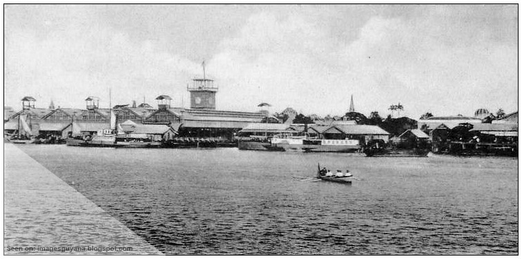
The Georgetown Ferry Stelling is a dock/wharf located behind the Stabroek Market. This stelling provides a river crossing from Georgetown (right bank of the Demerara River) to Vreee-en-Hoop (left bank of the Demerara River). The main mode of passenger transportation is by private speedboats. The image shows the Stelling from the Demerara River in 1920s British Guiana.


Sources
[image] West Indian View, Series IV, British Guiana


18 April 2017

The Lamaha Canal

The intricate network of canals and drains in Demerara, particularly in Georgetown, were developed primarily by the Dutch during their rule in the colony starting in the 1600s. The Dutch, French and British occupied this territory at various times. In 1814, the three colonies of Essequibo, Demerara and Berbice came under official UK rule and British Guiana emerged. The British subsequently filled in SOME of the Georgetown canals to create the tree-lined avenues of the Garden City.

Image 01 - Lamaha Canal, Georgetown (1910)
Sources:

[image 01] - Unknown